 Pristupačnost
a.1. Region under study
The area of proposed multidisciplinary seismological and seismotectonic research covers a part of the central–NW External Dinarides in Croatia centred at Mt. Velebit as shown in Fig. a1. It also includes the NW part of the Adriatic offshore between the Mt. Velebit and Dugi Otok Island, as well as the Lika region in Mt. Velebit’s hinterland up to the border with Bosnia and Herzegovina. In order to compare seismicity, structural styles, tectonic history and shallow to crustal-scale structures between the study and neighbouring areas, we also plan to analyse geophysical and geological data available to the NW and SE of Mt. Velebit as roughly outlined by the blue rectangle in Fig. a1.
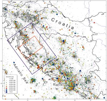
Fig. a1. Project study area of Mt. Velebit including the foreland of the Adriatic offshore and the hinterland of the Lika region (rectangle in red) and the surrounding region planned for partial seismotectonic profiling (rectangle in blue). Seismicity (BC–2013, only reliably located events) is after the Croatian earthquake catalogue (updated version described in Herak et al., 1996).
a.2. Geology and seismotectonic setting
The fold-thrust belt of external Dinarides formed by a thin-skinned Cenozoic thrusting along the eastern Adriatic plate margin (e.g. Blašković, 1988; Herak, 1991; Tari, 2002; Tari Kovačić and Mrinjek, 1994; Schmid et al., 2008; Korbar, 2009; with references), as a result of long-lasting convergence between the African, Adriatic and European plates in this part of the Mediterranean (e.g. Channell & Horváth, 1976; Dercourt et al., 1986; Stampfli and Borel, 2002).
Adria–Europe convergence started during the Middle Jurassic and initiated a closure of the intervening Neotethys Ocean, as documented by ophiolite obduction over the eastern Adriatic plate margin units during the Middle–Late Jurassic (e.g. Pamić et al., 2002; Tomljenović et al., 2008; Schmid et al., 2008). Subsequent progressive closure of the Neotethys, controlled by the NE-directed subduction of the Adriatic plate underneath the European derived tectonic units of Tisa, finally terminated along the Sava Suture Zone of internal Dinarides during the Latest Cretaceous–Earliest Paleogene (e.g. Pamić, 2002; Schmid et al., 2008; Ustaszewski et al., 2010).
In all studies dealing with tectonics of the Dinarides, it is unexceptionally proposed that following the closure of the Neothethys along the Sava Suture Zone, and due to the still prevailing Adria–Europe convergence, thrusting gradually propagated to the southwest into external part of the orogen, thus leading to the formation of the external Dinarides fold-thrust belt (e.g. Tari, 2002; Schmid et al., 2008; Korbar, 2009; Ustaszewski et al., 2008, 2010). Propagation of thrusting was associated with a migration of foreland basins that are progressively younger along the external belt toward the SE, and to the SW into the Adriatic offshore (Tari, 2002), filled by syn-orogenic flysch deposits of the Middle–Late Eocene (e.g. Babić et al., 2007; Marjanac et al., 1981), Oligocene (e.g. Tari Kovačić and Mrinjek, 1994; Korbar, 2009) and Miocene age (e.g. de Capoa et al., 1995; Tari-Kovačić et al., 1998; Mikes et al., 2008).
At present, the Adria–Europe convergence is still ongoing across the eastern Adriatic–Dinarides region at GPS velocity rates of 2–5 mm/yr (e.g. Grenerczy et al., 2005; Bennett et al., 2008; Caporali et al., 2009; Weber et al., 2010), partly accommodated by thrusting and strike-slip faulting, non-uniformly distributed along the fold-thrust-belt, as indicated by recorded seismicity (Fig. 1a).
It appears that the most active thrusting is currently taking place in the south-eastern part of the fold-thrust belt in Dalmatia, Montenegro and Adriatic off-shore (e.g. Herak et al., 2005; Bennett et al., 2008; Tomljenović et al., 2009), triggering some of the strongest earthquakes in this part of the Mediterranean: e.g. the M = 7.2 Dubrovnik earthquake in 1667 (Papazachos et al., 2009), the M = 7.1 Montenegro earthquake in 1979 (Benetatos and Kiratzi, 2006), and the M = 6 Ston earthquake in 1996 (Markušić et al., 1998). Almost as a rule, all recorded earthquakes in this part of the belt are supposed to be generated along the NE-dipping thrust faults, with calculated average long-term slip rates in their central segments between 0.7–2.5 mm/yr (Kastelic and Carafa, 2012). Delineated active faults in this part are considered either as individual or composite seismogenic sources capable to generate earthquakes with max. magnitudes between 6.5 and 7.5 (Kastelic et al., 2013).
In the north-western part of the external belt the most of ongoing tectonic activity is accommodated by dextral strike-slip faults in Slovenia (e.g. Vrabec and Fodor, 2006; Kastelic et al., 2008; Moulin et al., 2014), often considered as seismogenic structures responsible for the strongest earthquakes in this area (e.g. Bajc et al., 2001; Kastelic et al., 2008; Bavec et al., 2013), associated with subordinate thrusting in the Gulf of Trieste documented by Busetti et al. (2010). Dextral strike-slip faulting is also supposed as recently active along the eastern coastline of the Bay of Kvarner in Croatia, where the concentration of epicentres is quite prominent and in a very good correlation with delineated traces of the dextral-reverse Ilirska Bistrica-Senj and Raša-Rijeka faults (e.g. Prelogović et al., 1995; Kuk et al., 2000) or with the Vinodol-Rijeka fault, the latter considered by Kastelic et al. (2013) as a composite seismogenic source capable of triggering earthquakes with max. magnitude of 6.0.
When compared with the areas to the NW and SE, the proposed study area is characterized by conspicuously lower instrumentally recorded seismicity (Fig. a1). However, this seems strange due to the fact that the longest thrust fault in this part of external Dinarides, almost unexceptionally proposed in published papers, is considered as recently active, seismogenic source (e.g. Kuk et al., 2000) capable to generate earthquakes with magnitude of 6.5 (for details see in Kastelic et al., 2013). In most of papers this fault is named as the Velebit fault (e.g. Herak and Bahun, 1979; Tari Kovačić and Mrinjek, 1994; Prelogović et al., 1995; Ivančić et al., 2006; Kastelic and Carafa, 2012 with references) or more recently as the NE Adriatic fault (Korbar, 2009) (Fig. a2).
Following the work of Herak and Bahun (1979), the Velebit fault is commonly interpreted as the NE-dipping thrust (see Fig. a2A) that strikes along the toe of the SW-slope of the Mt. Velebit, however, covered by the Tertiary carbonate breccia known as the Jelar deposits (Bahun, 1963) or the Velebit breccia (Vlahović et al., 2012), and thus not directly exposed at the surface. Due to this coverage, the tip of the Velebit fault is alternatively supposed as submerged by the Adriatic Sea just offshore along the Mt. Velebit’s coastline (e.g. Bahun, 1974; Prelogović et al., 1995, 2004)
Recently, however, Korbar (2009) replaced the SW-propagating Velebit thrust, originally proposed by Herak and Bahun (1979), with a transpressive, dextral-reverse fault named as the NE Adriatic fault (Fig. a2). According to the same author, this fault is supposed to extend along the eastern Adriatic coastline all the way from Montenegro in the SE up to the Bay or Kvarner in the NW (see Fig. 4 in Korbar, 2009). In the area of Mt. Velebit, the author proposed that it overprints the Late Eocene SW-vergent nappe contact between supposed Dinaridic and Adriatic units in a form of a positive-flower structure, thus proposing a poly-phase tectonic evolution of the Velebit structure, also previously proposed by Bahun (1974) but in different tectonic scenario.
Finally, it has to be pointed out that a possible existence of a prominent fault, located either at the toe of the SW Mt. Velebit slope or in the area between the Velebit and the first chain of islands in the Adriatic offshore, is not indicated neither on geological maps nor in accompanying cross-sections of the Basic Geological Map of SFRY 1:100’000 sheets Gospić (Sokač et al., 1974), Zadar (Majcen et al., 1970) and Obrovac (Ivanović et al., 1973).
Therefore, we are of the opinion that proposed interpretations regarding the existence, location, geometry, kinematic history, recent activity and seismogenic potential of the fault along the toe of the Velebit SW slope, either known as the Velebit thrust or as the NE Adriatic fault, are controversial and highly debatable, and have to be reconsidered by a more detailed study.

Fig. a2. Geological cross-sections showing different interpretations of shallow- to crustal-scale structure of the study area centred at Mt. Velebit: A) from Kastelic at al. (2013) showing NE-dipping Velebit thrust fault considered as the composite seismogenic source HRCS005, and B) from Korbar (2009) showing transpressive, dextral-reverse NE Adriatic fault at the same location. See text for further explanation.
Besides these controversial interpretations regarding the Velebit thrust, there are also still open or not yet addressed questions regarding geometry, kinematic history and potential recent activity of major 10s–of–km–long faults shown on 1:100’000 sheets of the Basic Geological Map of the former Yugoslavia covering the Mt. Velebit area, like the Bakovac fault (Velić et al., 1974; Sokač et al., 1976), Brušane fault, Lika fault and Paklenica fault (Sokač et al., 1974, 1976). Namely, these faults are neglected and marginalised in almost all later studies aimed at the evaluation of their recent activity and a possible seismogenic potential, and also in reconstructions of subsurface structure and tectonic history of this part of the external Dinarides.
Accordingly, these issues will be among major objectives in the proposed study led by the tectonic group of the project team, aimed at delineation of shallow to crustal-depth structures, reconstruction of tectonic history and evaluation of ongoing tectonic activity in the study area.
a.3. Seismicity and seismic moment-release rate, seismic hazard
Even a superficial look at Fig. a1 reveals that the Mt. Velebit area (red rectangle) exhibits conspicuously lower seismicity than the neighbouring regions to the NW (greater Rijeka area) and to the SE (greater Zadar–Šibenik area). Instrumentally recorded earthquakes there are shallow, weak to moderate, with very rare events exceeding magnitude M = 5. As such, this region has been considered less interesting from the hazard point of view, and has been the object of no dedicated detailed seismicity study so far. However, seismicity overviews in the larger context of Croatian seismicity can be found in Milošević (1980), Herak et al. (1991), Markušić et al. (1993, 1998), Ivančić et al. (2002, 2006), whereas individual earthquakes there were studied by Živčić and Allegretti (1983). The earthquake catalogue completeness in this area is worse than in the neighbouring regions. Today’s completeness threshold, estimated at about magnitude 2.8, has been achieved only recently, thanking to the installation of stations NVLJ (2002), SLUN (2005) and UDBI (2009), and an instrumental upgrade of KSY (see Fig. b1). However, due to the scarcity of seismic stations the uncertainties of epicentral coordinates, and especially the focal depth, are still much too large, often exceeding 15 km for weak events.
The seismicity there – just as along the entire NE Adriatic coast – is caused by interaction of the Adriatic microplate (rotating counterclockwise around the pole in N Italy, although most probably not as a single rigid plate (Devoti et al., 2008) as originally suggested by Anderson and Jackson (1987)) and the Dinarides. South of Split, the Adria–Europe convergence is mostly accommodated within the External Dinarides (Fig. a3) by numerous earthquakes; the moment release rate drops suddenly between Zadar and Split (between lines 1 and 2 in Fig. a3) and the majority of seismic moment is currently released within the Internal Dinarides (Banja Luka region); around Rijeka and more to the NW the stress release is again the largest close to the Adria–Europe collision front (close to the coast). However, the coastal region between Jablanac and Zadar (the Mt. Velebit area), as well as the stripe towards NE all the way to the Pannonian basin (between lines 2 and 3 in Fig. a3) is seismically very quiet, even if the reliably known historical earthquakes are counted in (Fig. a1). It is, however, important to note that the strongest earthquake in the Croatian Earthquake Catalogue is the one that in the year 361 supposedly destroyed the ancient town of Cissa (today’s Caska) on the Pag island, whose ruins are seen today submerged under the sea. The catalogue references more disastrous historical events close to or within the Velebit area, all of which are marked as unreliable, e.g. the earthquakes in Lika (1505, Io = IX° MCS; ), close to Zadar (1280, 1300, 1399, 1768, all with epicentral intensity Io = IX° MCS), Senj (1648, Io = VIII° MCS), and Dugi otok (1343,1418, Io = IX° MCS), or in the Adriatic Sea (361, Io = X° MCS; 1626, Io = IX° MCS).


Fig. a3. Left: Seismic moment release rate after the seismicity model of Croatia and neighbouring regions (after Ustaszewski et al., 2014). Right: Croatian seismic hazard map – PGA for the return period of 475 years (Herak et al., 2011; CSI, 2011).
The apparent low level of seismic activity in the Mt. Velebit region is – to the best of our knowledge – not readily explainable. In fact, according to the tectonic understanding of the circum-Adriatic region, this quiescent region is not expected to exist at all! This is also confirmed by a recent modelling effort by Kastelic and Carafa (2012), who estimated average slip rates of major seismogenic faults in the External Dinarides. Their analyses show that the long-term slip rates of the Velebit thrust fault should be comparable to the activity of some of the large internal thrusts in Dalmatia. An average estimated slip-rate of 0.24 mm/year on the Velebit fault is larger or comparable to the slip rates estimated on the faults to the NW (e.g. the Vinodol–Rijeka fault, 0.15 mm/year). This is contradicting instrumentally observed seismicity (Fig. a1), which is much higher in the Vinodol–Rijeka area than in the region of the Mt. Velebit! Unlike the case of the area between Zadar and Split, where apparent lack of activity seems to be compensated in the Internal Dinarides, no such active region is seen to the NE of the Velebit region. Long-term earthquake rates in the Dinarides were also the subject of research by Carafa and Kastelic (2014), and in the broader scope of the Mediterranean (e.g. by Howe and Bird, 2010).
Of course, the low seismicity in the Mt. Velebit area is also reflected in the probabilistic seismic hazard estimates which heavily rely on the information in the earthquake catalogues. Croatian seismic hazard maps (Fig. a3; CSI, 2011; Herak et al., 2011; http://seizkarta.gfz.hr), as well as the recent SHARE hazard maps (Giardini et al., 2013; see also Hiemer et al., 2014 who investigate earthquake rates in Europe) both feature a prominent low-hazard area in the Mt. Velebit region.
a.4. Fault-plane solutions, stress-field
Only about a dozen published fault-plane solutions (FPS) exist for the greater study area, and only one in the Mt. Velebit region itself (Herak et al., 1995). Fig. a4 shows very preliminary results obtained by Herak and Herak (2014) who supplemented and (re)processed all of the data in the Croatian FPS-database. Their results mostly agree within the expected uncertainties with independent CMT-estimates. Although most of the solutions point to pure-to-oblique thrust faulting, a number of predominantly dextral strike-slip solutions were obtained in the Mt. Velebit and Lika areas. The inferred directions of predominant stresses (P-axes) are mostly SW–NE or SSW–NNE (in agreement with the results of Kastelic and Carafa, 2012, or Carafa and Barba, 2013), with a distinct local rotation into the S–N direction in the areas of the Kvarner Bay and between Novi Vinodolski and the Northern Velebit.

Fig. a4. Black – preliminary first-motion polarity solutions (M. Herak and D. Herak, 2014, unpublished), blue, green – CMT best double couple reported by MEDNET (2014) and SED (2014), respectively. Red bars – direction of the P-axes.
a.5. Structural models, crustal thickness and lithospheric processes
To the best of our knowledge, only one study (Herak and Herak, 1995) addressed the velocity structure of the crust and upper mantle of the Mt. Velebit region using earthquake-generated body-waves travel-time analyses, even only in the wider context of the circum-Adriatic region. They found the longitudinal wave velocity in the upper crust of about 6.0 km/s, and showed that Pg-arrival time station corrections for the stations in the Velebit area are positive (unlike all surrounding areas where they are negative).
The Moho topography for the greater Adriatic region was presented in Skoko et al. (1987). Crustal thickness map from Skoko et al. (1987) shows general pattern of thicker crust under the Dinarides reaching maximum of 45 km in the southern Dinarides and thinning towards the Pannonian basin and the Adriatic Sea. Results of early active experiments (most importantly the ones related to the DSS profile Dugi otok–Virovitica) were presented by e.g. Dragašević (1974) and Dragašević and Andrić (1982). Detailed research of the crustal properties in the Dinarides was subsequently published by Aljinović (1984). More recently, Orešković (2010), Stipčević et al. (2011) and Stipčević (2012) performed the receiver functions analyses of the greater Dinarides area (see also Van der Meijde et al., 2003). Results of receiver function modelling from these investigations point to higher values of crustal thickness in the Central and Southern Dinarides (>50km), crust thinning northwards before reaching local minima in the Lika–Velebit area (~40km) and again thickening in the North-Western Dinarides going towards the Alps. Studies of Šumanovac et al. (2009) and Orešković (2010) using the active seismic source measurement in the course of the ALP2002 experiment indicate that the crust in larger Velebit area can be subdivided into three parts – Adriatic crust, transitional zone towards the Panonnian basin and the Pannonian crust. Adriatic crust is characterized by deep Moho and pronounced midcrustal discontinuity, which slowly disappears in the rapidly thinning crust of the transition zone. Panonnian zone is characterized by the extremely low velocities in the upper several kilometres of the crust but can otherwise be described as uniform although relatively slow (P velocities less than 6.2 km/s). Furthermore, analysis of the teleseismic data from several stations in the greater Mt. Velebit area (Kukača, Slunj, Udbina, Kosinj) points towards complex crustal structure with highly varying Moho depths between southern (Udbina, Kosinj) and northern (Kukača, Slunj) stations (Stipčević, 2012). Crustal thickness in this relatively small area varies from 50 km in the south to 40 km in the north. Signal coming from Mohorovičić discontinity is highly pronounced in two southern stations while the stations in the north show highly attenuated Moho signal. These measurements in conjunction with the results of the regional teleseismic tomography showing large anomalous body of low velocity in the upper mantle beneath this area (Lippitsch et al., 2003; Piromallo and Morelli, 2003; Mitterbauer et al., 2011) hint at the possible upwelling of the hot astenospheric material and thermal erosion of the otherwise continuous Adriatic lithosperic slab (Ustaszewski et al., 2008).
a.6. Attenuation
Seismic waves’ attenuation properties in the greater Dinarides region was studied by Dasović et al. (2012, 2013), who computed lapse-time dependent coda-Q values for all stations of the Croatian network. Results for stations in the Velebit area stand out by the irregularity of the lapse-time dependence of Qc, and by smaller–than–average attenuation for small lapse-times (30–50 s). The frequency dependence of Qc is pronounced, but does not significantly differ from the near-by regions.
a.7. Anisotropy
No dedicated anisotropy study has been performed in the study area. One paper dedicated to anisotropy of Pg-waves in the Central External Dinarides (just to the SE of the Velebit area) was published by Lokmer and Herak (1999), who found a pronounced anisotropy with fast axes parallel to the principal stress direction revealed by FPS. The observed anisotropy was modelled by assuming a system of vertical/subvertical cracks in the upper crust, aligned under the influence of the regional tectonic stress field. Schmid et al. (2004) measured SKS splitting parameters for stations HVAR and DUGI, but on a very small set of data. Some preliminary results on splitting of the local Sg-phase were also published by Allegretti et al. (2010).
a.8. Other relevant research
Here we’ll only briefly report on studies related to the submerged tidal notches that are observed along the Croatian Adriatic coast between Rijeka and Zadar (e.g. Benac et al., 2004, 2008; Faivre et al., 2010; Stiros and Moschas, 2012; Marriner et al., 2014). The authors find the submerged notches to be well preserved and approximately at the same depth of 50–60 cm (except in the bay of Bakar). Notable absence of the tidal notch at the present-day sea level, the preserved notch morphology (especially its roof), as well as the sharp contacts in the salt-marsh litho- and biostratigraphies (as observed at the Caska site by Marriner et al., 2014; see also the paragraph on seismicity above!) suggests that the rapid, probably co-seismic, sea-level change has occurred there, which the authors date around the years 1000–1200 AD. Stiros and Moschas (2012) studied the notch in the Bay of Bakar and also arrive at the conclusion that an unknown earthquake of at least magnitude 6.8 must have occurred in the last few centuries in that area. Benac et al. (2004) suggested that the fast regional subsidence occurred after the Roman times, possibly between the 4th and 6th centuries. If these interpretations are correct, the consequences for the seismic hazard in all of the Kvarner region and the Mt. Velebit area are huge, as they suggest that the present day lull in seismic activity is merely a quiescence in otherwise active region.
a.9. Networks of seismological stations
As already mentioned, the density of seismograph stations in the Mt. Velebit area is much too low to allow accurate locations of weak earthquakes. Although the situation did improve in the last decade, today only two stations operate within 50 km from the centre of the Velebit range, and another 6 are found within 100 km radius (Fig. b1). In Croatia the stations are operated by the Department of Geophysics of the Faculty of Science, University of Zagreb, either as a part of the national network managed by the Croatian Seismological Survey (BRJN, CACV, DBRK, DUGI, HVAR, KALN, KIJV, KSY, LSTV, MAKA, MORI, MOSL, PTJ, RICI, RIY, SLNJ, STA, ZAG, ZIRJ), or financed through the national research projects (NVLJ, OZLJ, STON, UDBI). For stronger events data from the Slovenian and Italian networks contribute to better constrained focal locations and to more reliable FPS.