 Oobjavljen je prvi multidisciplinarni znanstveni rad o Petrinjskom potresu u prestižnom časopisu Remote Sensing:
Markušić S, Stanko D, Penava D, Ivančić I, Bjelotomić Oršulić O, Korbar T, Sarhosis V. Destructive M6.2 Petrinja Earthquake (Croatia) in 2020—Preliminary Multidisciplinary Research. Remote Sensing. 2021; 13(6):1095. https://doi.org/10.3390/rs13061095
Sažetak (eng,) pod "Pročitaj više" u nastavku
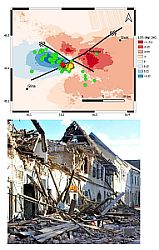
On 28 December 2020, seismic activity in the wider Petrinja area strongly intensified after a period of relative seismological quiescence that had lasted more than 100 years (since the well-known M5.8 Kupa Valley earthquake of 1909, which is known based on the discovery of the Mohorovičić discontinuity). The day after the M5 foreshock, a destructive M6.2 mainshock occurred. Outcomes of preliminary seismological, geological and SAR image analyses indicate that the foreshocks, mainshock and aftershocks were generated due to the (re)activation of a complex fault system—the intersection of longitudinal NW–SE right-lateral and transverse NE–SW left-lateral faults along the transitional contact zone of the Dinarides and the Pannonian Basin. According to a survey of damage to buildings, approximately 15% of buildings were very heavily damaged or collapsed. Buildings of special or outstanding historical or cultural heritage significance mostly collapsed or became unserviceable. A preliminary analysis of the earthquake ground motion showed that in the epicentral area, the estimated peak ground acceleration PGA values for the bedrock ranged from 0.29 to 0.44 g. In the close Petrinja epicentral area that is characterized by the superficial deposits, significant ground failures were reported within local site effects. Based on that finding and building damage, we assume that the resulting peak ground acceleration (PGAsite) values were likely between 0.4 and 0.6 g depending on the local site characteristics and the distance from the epicentre.
Keywords: Petrinja earthquake; Dinarides; Pannonian basin; strike-slip faults; Kupa Valley (Pokupsko); SAR images; land displacement; building damage; local soil effects
 Pristupačnost